
Navigazione principale

  • About
  • Products
  • Data access
  • Collaborate
  • News and events
  • Resources
  • Training
  • Notifications
  • EFAS Wiki

Past events

3rd CEMS Global Flood Forecasting and Monitoring Annual Meeting

3rd CEMS Global Flood Forecasting and Monitoring Annual Meeting : 5-6 March, REGISTER NOW!

Mon, 22/01/2024 - 12:00

Would you like to learn about the most recent developments to the CEMS Global Flood Awareness System (

3rd CEMS Global Flood Forecasting and Monitoring Annual Meeting

3rd CEMS Global Flood Forecasting and Monitoring Annual Meeting : 5-6 March, save the date!

Wed, 03/01/2024 - 12:00


Register now EFAS v5.0 Webinar on 17 November 2023

Fri, 17/11/2023 - 12:00

The webinar is scheduled on 17 November 2023  at 15:00-16:00 CET (14:00-15:00 UTC). 

Copernicus Emergency Management Service Annual Conference 2023

Tue, 05/09/2023 - 12:00

Join us on t

Global Flood Monitoring Product Release Workshop, April 28th

Thu, 28/04/2022 - 12:00

The Copernicus Emergency Management Service has been developing  a new

Global Hydrological Workshop 2021

Global Hydrological Workshop 2021 - Event reminder

Tue, 29/06/2021 - 12:00

ECMWF are hosting a three-day virtual event titled "Connecting global to local hydrological modelling and forecasting: scientific advances and challenges" from

Global Hydrological Workshop

Global to local hydrological modelling and forecasting - virtual event

Wed, 31/03/2021 - 12:00

ECMWF will host a three-day virtual event titled "Connecting global to local hydrological modelling and forecasting: scientific advances and challenges" from 29 June 2021

Figure 1: The medium-range forecast skill layer. Including the 436 new points, a total of 3087 reporting points are now shown.

Release of New EFAS Version 4.2

Thu, 18/02/2021 - 12:00

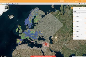
A new version of EFAS, EFAS 4.2, is to be released operationally 24 February 2021 during the afternoon.

Figure 1: ERIC reporting points in northern Ireland. Enlarged inverted triangles highlight where the flash flood forecast probability and lead time meet the criteria for issuing a flash flood notification (shown by the blue triangles).

Release of New EFAS Version 4.1

Fri, 12/02/2021 - 12:00


TAMIR Logo

Online TAMIR Workshop - Tools for Impacts and Risks Induced by Severe Weather

Tue, 27/10/2020 - 12:00

The TAMIR project welcome you to the first end-user workshop on tools for management of impacts and risks induced by severe weather with special emphasis on floods.

Pagination

  • Page 1
  • Next page ››

Map viewer

Training

Data Download

Copernicus Services:
Atmosphere Marine Land Security Climate Change Emergency
Contact
Follow us
Copernicus

Copernicus is an EU programme aimed at developing European information services based on satellite Earth Observation and in situ (non space) data. Copernicus is a user driven programme and the information services provided will be freely and openly accessible to its Users, mostly public authorities.

  • Terms and conditions
  • Privacy statement
  • Cookies
  • feed rss RSS
  • Contact us