Flood impact forecasts are especially important in the preparedness phase, to support the planning and allocation of rescue assets, and to get a first estimate of the forecasted flood event’s potential socio-economic consequences. During large-scale flood events, EFAS impact forecasts can be used to pre-task the acquisition of satellite images for a possible activation of the rapid mapping component of the Copernicus EMS.
In EFAS, the flood impact forecasts are based on three components: 1) medium-range flood forecasts, 2) event-based rapid flood mapping, and 3) impact assessment.
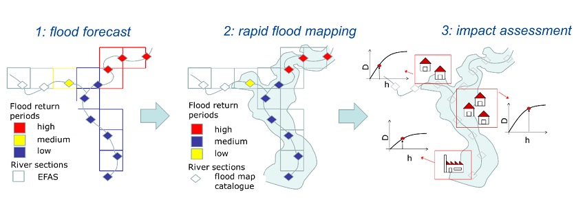
Medium-range flood forecast: every time a flood event is forecasted in EFAS, the magnitude of the forecasted peak discharge (based on the ECMWF-ENS EFAS ensemble forecast median for the full forecasting period) is compared against the EFAS flood protection levels. River grid cells where the protection levels are exceeded are selected for the following steps of the procedure.
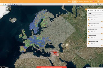
Rapid flood mapping: for each EFAS river section identified in step 1, flood prone areas are delineated, using a catalogue of flood inundation maps. The obtained event-based flood inundation map has a spatial resolution of 90 by 90 m and is shown on the “Rapid Flood Mapping” layer.
- Impact assessment: the event-based flood inundation maps are combined with exposure information to assess regional impacts (shown on the “Rapid Impact Assessment” layer). Considered exposure includes population, infrastructure and land cover. The rapid impact assessment considers two scenarios, protected and unprotected:
- Protected scenario: exceeding 10 year return period or protection level, where the protection level is based on the estimated design return period for flood defenses (e.g. dikes), assuming any flood event over the protection level, will cause flooding. The data on level of protection offered by flood defenses comes from the dataset FLOPROS and is available at administration region level. To get an overview on the flood protection levels used within the different areas of interest, have a look at the 'flood protection level' layer in the EFAS Map Viewer.
- Unprotected scenario: exceeding 10 year return period.
In addition, there is a good overview on the data used to produce these products in the Wiki under CEMS- Flood general information.